Monday, October 8, 2018

Michael Threatens North Florida, Get Ready!

Michael is looking like a significant threat to the Northeast Gulf Coast.  The storm is a strong tropical storm for now, likely to be a hurricane sometime later today.


The storm is forecast to be close to major hurricane status when it impacts the Florida Panhandle or Big Bend, probably on Wednesday:

cone graphic

Hurricane watches are already up for all of the Panhandle and Big Bend.

Some of the model forecasts for the storm are quite concerning:

https://twitter.com/RyanMaue/status/1049246905564372993

The European weather model is forecasting over 100 mph wind gusts to extend inland all the way to Tallahassee. If this happens, it would be a significant problem in terms of power outages, and damage to trees, roofs, and even some structures.

I urge everyone in the watch areas, and well inland, to finalize preparations today.  The storm will probably make landfall sometime Wednesday late morning or afternoon, but nasty weather could arrive as soon as tomorrow night:

time of arrival graphic

As the forecast shows, Michael may also impact the Carolinas with wind and rain after moving inland, which is not a welcome situation after the devastating flooding of Florence last month.  This storm should be moving much more quickly, but even a few more inches of rainfall could be extremely problematic.

Here are some preparedness links:

National Hurricane Center

Florida Evacuation Zones

FSU Hurricane History and Preparedness

City of Tallahassee Hurricane Preparedness

Please take this storm seriously, and be safe.

Andy


Saturday, October 6, 2018

Potential Tropical Cyclone 14 Forms - Soon to be TS Michael

The area of interest in the NW Caribbean has been classified as "Potential Tropical Cyclone 14".  The "Potential Tropical Cyclone" classification indicates that a system is not quite a TD or TS yet, but is expected to form into one soon, and NHC writes advisories and issues watches and warnings.  The system will likely continue to grow, and may become Tropical Storm Michael by tomorrow.

The system is currently spanning much of the NW Caribbean, and slowly getting better organized (satellite image from www.weathernerds.org):


Here is the initial forecast from NHC for the track of the system:

cone graphic

Right now the forecast is for the system to be a tropical storm at landfall, but it certainly has a chance to become a hurricane, and residents of the northern Gulf Coast should prepare accordingly.

The system will likely make landfall Wednesday morning or afternoon somewhere between far SE Louisiana and the FL Big Bend.  Right now, models are honing in on the FL Panhandle region, but until the system is fully formed the tracks will be somewhat uncertain.

This has the potential to be a fairly "short-fuse" storm - i.e., not a lot of time between when it forms and when it hits.  And it could strengthen more than shown here.  So be ready if you live anywhere along the Northern or Eastern Gulf!

Andy

Friday, October 5, 2018

Tropical Trouble Ahead in the Gulf?

Hello Everyone!

After a few quiet(ish) weeks in the tropics after Florence and Gordon, some late-season action appears to be on the table.  An area of low pressure in the Caribbean near the Honduras/Nicaragua border may develop into a tropical storm as it lifts into the Gulf of Mexico late this weekend and early next week.  Here's a current satellite picture (from www.weathernerds.org):


The system is currently asymmetric, sheared by strong upper-level winds.  However, this shear may weaken some as it moves into the Gulf of Mexico, allowing a tropical system to develop.  If a storm does develop, models indicate it will likely move towards the northern/eastern Gulf Coast, with the Florida Panhandle or Big Bend looking most likely at the moment.  This is a common track for October storms forming in this region. 


The figure above was plotted using the website (https://www.coast.noaa.gov/hurricanes/), and shows all October storms that were Tropical Depressions/Storms in the southern Gulf in October.  Most of these systems end up traveling towards the North Central or Northeast Gulf. 

Still a lot of uncertainty as to whether and when something will form, but it's a good time to make sure your hurricane plans are still ready to go along the Gulf Coast.  The season still has a ways to go!

Andy

Tuesday, September 11, 2018

Florence Approaches The Coast; Isaac Worth Watching; a Possible New System in the Western Gulf

Hello all,

Hurricane Florence is heading towards the SE US Coast as a Category 4 Hurricane.  The storm is menacing and powerful:


Image From NASA


Here is the latest forecast from the National Hurricane Center:

cone graphic

Hurricane watches are up for most of the coasts of SC and NC, and people living in these areas, and even down to coastal Georgia, need to finalize their hurricane plans.  While the worst surge and wind will be along the coast, people inland need to take this seriously, too.  The storm will be slowing down, and rainfall amounts could be very high.  Inland flooding is one of the most deadly parts of hurricanes, so be prepared if you live inland. As you can see, NOAA is predicting inches to even feet of rain well inland:


Tropical Storm Isaac is also worth watching.  The storm is not particularly well organized at the moment, but could bring some strong winds and heavy rain to the Caribbean Islands. Hurricane Watches are in effect for the Lesser Antilles.  The storm may weaken in the Caribbean, but it's too early to say if it will fully dissipate, so just keep an eye on it in the US!

cone graphic

Finally, there is a system being watched near the Yucatan peninsula for possible development.  It may become a tropical storm over the Western Gulf of Mexico later this week, and could bring heavy rain to southern Texas and northern Mexico, as you can see in the rainfall forecast above.  Here is the current satellite picture of the system:


Image From NASA

Let me know if you have any questions!

Andy

Saturday, September 8, 2018

Florence a Major Threat, Isaac Worth Watching

Hello all,

Hurricane Florence is a major threat to the US East Coast.  Here's the latest 5-day track cone from the National Hurricane Center:

cone graphic

The storm is forecast to strengthen quickly starting tomorrow, and will likely become a major hurricane sometime early next week.  Right now, models are starting to hone in on the closest approach and potential landfall being in the Carolinas, but there is still enough spread (see below) that anyone between NE Florida and the mid-Atlantic needs to continue watching it.  I would begin to make hurricane preparations if I lived along the Carolinas coastline.


Image from www.weathernerds.org

Tropical Storm Isaac has formed out in the Central Atlantic.  It is forecast to slowly strengthen and may become a hurricane next week.  Right now, the forecast brings it into the Lesser Antilles as a hurricane in 5 days.  The storm could weaken in the Caribbean due to strong wind shear, but should be watched warily in the Southern US in case it survives. 

cone graphic

The Atlantic remains active, so just be on alert, and again if you live near the projected path of Florence make sure to begin preparations now!

Andy

Friday, September 7, 2018

Hurricane Florence Threatens East Coast, Active Atlantic Behind

Hi all,

As I mentioned, the Atlantic is heating up quite a bit, and there is a storm to watch near Hawaii again!  There have been several storms recently, with some ongoing.  I'll take them one at a time.


TS Gordon
Gordon made landfall as a 70-mph Tropical Storm near the Mississippi/Alabama border.  This area is quite used to tropical systems, and thankfully the storm didn't do much damage (https://www.nytimes.com/2018/09/05/us/gordon-storm-updates.html).  Sadly, however, a child was killed by a tree falling on a mobile home.  This shows that mobile homes are not safe in any tropical system, no matter the intensity.

Hurricane Florence
Florence is by far the biggest threat in the Atlantic right now.  The storm rapidly intensified into a Category 4 storm, but then weakened just as quickly to a tropical storm, due to strong upper-level winds.  However, the atmosphere looks very favorable for it to reintensify back into a strong hurricane.  The computer models we use to predict the weather are starting to suggest that the storm will stay on a westerly heading, potentially threatening the U.S. East Coast next week.


Image From www.weathernerds.org

The most likely scenarios at this point are an impact in the Carolinas or a close brush before moving offshore.  However, there are still possibilities on the table ranging from an impact in N Florida to turning out to sea.  Everyone from Florida to New England should at least be thinking about your hurricane plan, and potentially get ready to implement it as things become more certain this weekend.  Here is the official 5-day track from the National Hurricane Center, the place to go for official hurricane information:

cone graphic
Image From www.nhc.noaa.gov

Hurricane Olivia (Pacific)
Hawaii already dealt with a close blow from Hurricane Lane recently, and now Hurricane Olivia may make a close approach and potentially a direct impact. 


Image From www.tropicaltidbits.com

The storm should be weakening as it approaches Hawaii, but could still be strong enough to cause major problems.  Now is a good time to start getting prepared in the Hawaiian Islands.


Wave #1 in the Atlantic
A wave in the Central Atlantic is close to becoming a tropical depression or storm.  It could be named Helene or Isaac (depending on if it forms before or after the next wave).


Image From https://weather.msfc.nasa.gov

This wave is still too far out to tell much about where it will end up, but it's starting fairly far south and could end up in the Caribbean, which has had a lot of tropical cyclone impacts the last two years (with Matthew in 2016 and Irma and Maria in 2017).  Definitely something to watch over the next week.


Wave #2 in the Atlantic
Finally, a very strong wave is moving off of Africa.  It may become a depression or storm (again, racing the other wave to get named first!) very soon.  It's even further out and may well turn out to sea over the Atlantic, but it's too early to say that for sure. We have even more time to watch this one.


Image From www.weathernerds.org

In summary, the Atlantic is very active right now, with Florence a major potential threat to the US, and two other systems behind to watch.  Now is a good time to review your hurricane plan, know your evacuation zone if you live near the coast or in a flood-prone area, and be prepared to take action, especially along the US East Coast.  

Let me know if you have any questions!

Andy

Saturday, September 1, 2018

Atlantic Becoming a Little More Active

Hello Everyone!

After one of the most inactive Augusts in recent memory (for the Atlantic; the Pacific was quite active and Hurricane Lane impacted Hawaii with torrential rain), September is looking more active in the Atlantic tropics.  There are a few areas of interest.  None are an immediate threat, but we'll look at them one by one.  As always, official forecasts can be found at www.nhc.noaa.gov.

Bahamas Wave

A tropical wave moving through the Bahamas right now has a 40% chance of becoming a tropical storm in the Gulf of Mexico early next week.  It probably won't get too strong due to some wind shear (strong upper-level winds), but the ECMWF (European) model does show some development before impacting Louisiana.  It will likely increase rain chances in Florida, especially Sunday and Monday.  The whole Gulf coast needs to pay attention.


Image from www.nhc.noaa.gov


Image from Tropical Tidbits

Tropical Storm Florence

Tropical storm Florence has formed off the coast of Africa.  The storm is likely to slowly strengthen over the next few days, and move off towards the West-Northwest.  There is quite a bit of long-term spread in the track forecasts for the storm, however.  It may very well turn north into the Atlantic well before coming near Bermuda or the U.S., but this is far from set in stone, and this system is worth watching.  It is still 10-15 days from being any kind of threat.


Images from weathernerds.org

Other Waves

Finally, the models show the active Atlantic continuing, with a couple more waves coming off Africa behind Florence with a chance to develop.  These are even further off from being even a slight threat, but just a reminder that the peak of hurricane season is near, and even though it's been quiet so far, that may not necessarily last.  Just keep your eye out and be ready as always!

Let me know if you have any questions!

Andy

Tuesday, August 21, 2018

Hurricane Lane Threatens Hawaii

A Hurricane in Hawaii?!?

It can happen.  The image below shows all the hurricanes since the late 1800s to come within 200 miles of Hawaii (see https://www.coast.noaa.gov/hurricanes/):


As you can see, it's rare, but it happens!  The strongest of these was Hurricane Iniki (http://www.hawaiinewsnow.com/story/36315106/hurricane-iniki-quick-facts-about-hawaiis-most-powerful-storm), which impacted the island in 1992.

Currently, Hurricane Lane is threatening the state, and models have recently shifted to show a path near or over the islands.  This is the current forecast from the Central Pacific Hurricane Center:


Lane is currently a very strong Category 4 storm (borderline Category 5) with 155 mph winds.  It may weaken some before approaching the islands, but could still be a very dangerous system with the potential to bring storm surge, strong winds, and heavy rain to multiple islands.

If you have friends, family, or other interests in Hawaii, make sure they are prepared for the hurricane!  Hopefully the worst will stay offshore, but a direct impact is possible, and bad weather is likely even if it doesn't directly hit.

The storm is well-observed, at least, and several of my colleagues from HRD are flying research missions into the storm:

https://twitter.com/NWSHonolulu/status/1031420462021128192

Feel free to let me know if you have any specific questions!

Andy

Thursday, August 2, 2018

Colorado State's Updated Seasonal Forecast

Hello everyone,

One of the most well-known forecasts of seasonal hurricane activity is from Colorado State University.  It was started by the late Dr. Bill Gray (my academic great-great grand-advisor), and continued by Drs. Phil Klotzbach and Michael Bell.  They issue forecasts at the start of hurricane season, and update them again at the beginning of August, prior to the typically active part of the Atlantic Hurricane Season (the season runs June-November, but the most active period by far is, on average, mid-August through mid-October).

This year's seasonal forecast from CSU has been released.  It is available at:

https://tropical.colostate.edu/media/sites/111/2018/08/2018-08.pdf

You can read the details there if you are curious.  Basically, there are a few key points.

1) The Atlantic is cooler than usual.
2) The Pacific is warming, heading towards a possible El NiƱo, which causes wind shear (see my first blog) that hampers Atlantic hurricanes.
3) Because of 1) and 2), the Atlantic is expected to be less active than usual this year.  In fact, CSU's model predicts some of the lowest activity since the very quiet years of the early 1990s.
4) ****This is the most important reminder*****.  Despite seasonal activity probably being below-average, it is impossible to predict an individual hurricane this far out.  Hurricane Andrew occurred in 1992, in a year that was otherwise very inactive.  So keep your guard up as we head into the peak of the season.

Let me know if you have any questions!

Andy

Saturday, July 21, 2018

Introduction and the Current State of the Atlantic


Hi all,

I'm going to be posting here with updates during Hurricane Season this year!

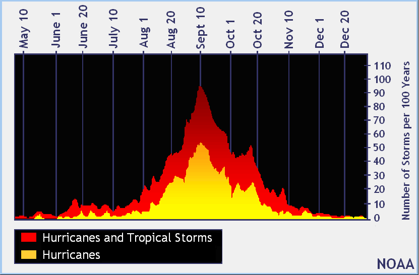
Right now, the Atlantic is quiet.  That's pretty typical for July. As you can see in the picture below from NOAA, the Atlantic season peaks around September 10, with mid-August through mid-October being the typical most active time.


Why is the Atlantic so quiet right now?  I won't get too much into the scientific details, but there is a lot of dry air (actually coming off Africa) out over the Atlantic and Caribbean.  There is also a lot of what is called "wind shear".  Wind shear is when the winds near the surface are very different from the winds up around the level where planes fly.  This graphic below (from the University of Illinois) explains it well.  When there is weak shear, thunderstorms can grow upright (good for hurricanes).  When there is strong shear (and especially when there is also dry air), thunderstorms have a hard time growing.


The Atlantic has also been cooler than normal so far this year, although that (and the wind shear!) can change quickly.  It may be a less active season than infamous 2017, but you can still get really bad storms even in "quiet" years (Andrew in 1992 was a good example).  Speaking of Andrew - the place we live now (see the pushpin in the picture below) is right where the full wrath of Andrew was felt (although the house we are renting wasn't built until 2004).  Kind of a weird feeling.


So the bottom line is, the Atlantic is quiet for now, but don't let your guard down as we head towards peak season.  I'll post updates as things heat up.  Here are some other good links for hurricane info:


Feel free to contact me if you have any questions, at andy.hazelton.1003@gmail.com.

Andy Hazelton