Friday, June 24, 2022

Invest 94L a Chance of an Early-Season Storm. Just Something to Watch for Now.


Invest 94L in the Central Atlantic

Overview

Happy Friday evening everyone! There is a tropical wave in the Central Atlantic ("Invest 94L") that bears watching. It's pretty early for stuff to develop out there but this has a chance to develop as it approaches the Caribbean. Side note - what is an "Invest"? Basically - that's what NHC calls a disturbance that they think *might* form into a tropical depression or more, but it's not organized enough yet. In this case, they are giving it a 60% (medium) chance of becoming a TD within 5 days:

Image 1: NHC's Tropical Weather Outlook From 2pm Friday, June 24, 2022
https://www.nhc.noaa.gov/gtwo.php?basin=atlc&fdays=5

Forecast for 94L

Right now the system is fairly disorganized. It will take some time to get together. Most models are bringing it into the Southern Caribbean. It could even get close to the "ABC Islands", which is pretty rare ever, especially this time of year. We'll have to see. Conditions look favorable ahead of it but it may take some time to get organized. Down the road, it could head towards Nicaragua and Honduras, or the Yucatan Peninsula of Mexico. Too far out to say if it will be a US threat at all, but hopefully the big ridge of high pressure that's made things so darn hot over the Southern US will also act to keep this south of the states.
Image 2: Infrared satellite image of Invest 94L as of 5:15 PM EDT on Friday, June 24, 2022
https://www.weathernerds.org/satellite

Image 3: ECMWF "ensemble" for Invest 94L, showing some of the possible tracks in the Caribbean. This will likely change some over time.
https://www.weathernerds.org/models/ecens.html

So in summary, nothing to panic about now, but a good reminder to make sure your hurricane plan is ready to go, as we approach the peak of hurricane season! Always pay attention to www.nhc.noaa.gov for the latest, official information. Stay safe out there!

Andy


Monday, August 9, 2021

Atlantic Starting to Get a Little Busier

 Hello Everyone!

It's now August 9 (hard to believe!) and we're getting closer to the peak of Hurricane season. 


In addition, a large-scale atmospheric wave called the MJO is moving into a phase that supports Atlantic storm formation. Thankfully there are no major imminent threats, although there is a wave near the Lesser Antilles Islands, "Invest 94L", that bears watching. 

Image from www.weathernerds.org

This wave may become a tropical depression or storm in the next day or two. A combination of wind shear from strong upper-level winds, dry air in the upper atmosphere, and land interaction with Puerto Rico and Hispaniola should keep it from getting too strong, but it's worth keeping an eye on. 

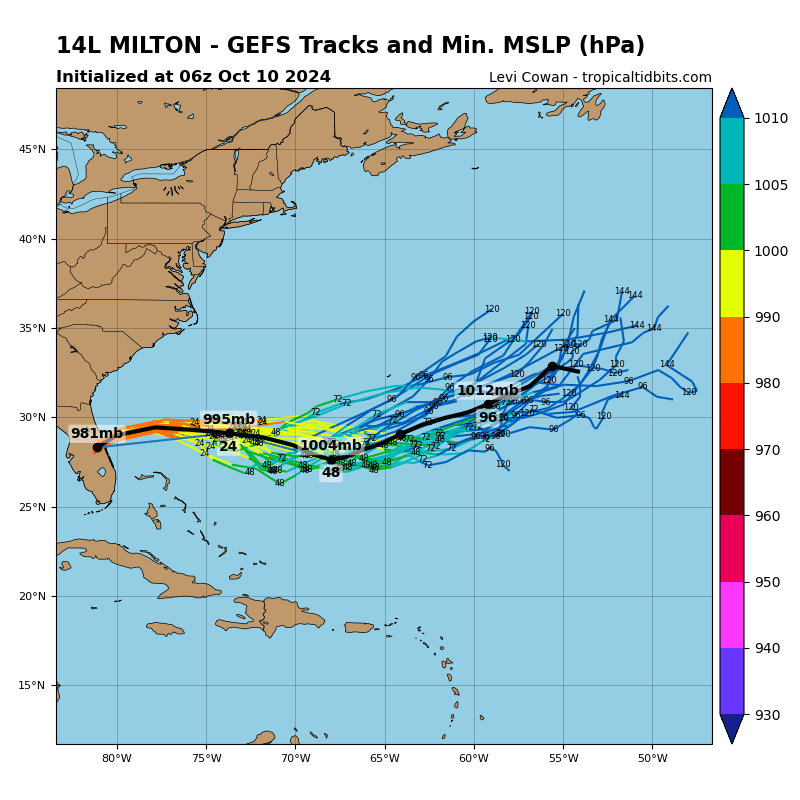
The plot below (from Tropical Tidbits) is an "ensemble", or a bunch of slightly different runs of the same model. This gives an idea of some of the different possible outcomes for this wave.


As you can see, most "ensemble members" track the storm near or along the Caribbean islands and generally towards the Florida Straits, but keep it weak due to some of the obstacles I mentioned above. So, hopefully, it won't be a very strong storm near Florida, but it's too early to say for sure. Either way, rain chances will likely increase this weekend for South and Central Florida.

Thankfully, no huge threats out there at the moment, but things are starting to heat up, so keep an eye on the tropics, and as always make sure you go to www.nhc.noaa.gov for the latest official information!

Andy


Tuesday, July 6, 2021

Tropical Storm Elsa Approaching Florida

 Good morning everyone!


As expected, Elsa is approaching the West Coast of Florida as a strong tropical storm this morning, with maximum sustained winds near 65 mph. 


Radar shows that the storm is lopsided, also expected. Most of the heavy rainbands are to the east and northeast of the center, due to some strong upper-level winds and dry air to the west of the storm. This is good because it will keep the storm from strengthening too much over the warm Gulf, but it means much of the West Coast of Florida and inland parts of the Peninsula will see some nasty weather from these bands today.

Radar Image out of Key West this Morning


Zoomed out Radar View

Tropical storm warnings are up for most of the Florida West Coast and Big Bend, with Tropical Storm watches up west to near Apalachicola. There is also a Hurricane Watch up from near Tampa to the Big Bend, as it is possible Elsa could reattain Category 1 hurricane status before making landfall. Impacts will be similar no matter what the official classification is. There are also Storm Surge Warnings up for most of the Florida West Coast. Water levels 3-5 feet above normal high tides are possible.

NHC Forecast Valid 8 am Tuesday, July 7, 2021

The main threats from Elsa today are:
1. Heavy rain over much of the Florida Peninsula.
2. 3-5 feet of Storm Surge over the West Coast of Florida. This could cause some problems depending on the timing relative to high tide.
3. Isolated tornadoes over the Florida Peninsula.
4. 60-70 mph wind gusts, especially near the coasts, causing some spotty power outages.

Be safe and hunker down!

Andy


Monday, July 5, 2021

Elsa's March North Continues

 Good Morning Everyone!

Elsa is continuing to move along this morning, now just southwest of Cuba. The storm has 65 mph winds (strong tropical storm). It will likely weaken a little bit when it moves over Cuba, but should still be a moderate to strong tropical storm in the Gulf of Mexico.

Image from www.tropicaltidbits.com

Elsa is forecast to move along or probably just offshore the west coast of Florida. The storm will be "sheared" from the west, such that most of the heaviest rain will be east and northeast of the center. This can be seen in an example forecast from the NOAA Global Forecast System (GFS) for Tuesday evening:

Image from www.weathernerds.org

Even if the shear keeps the storm from intensifying significantly, heavy rain and gusty winds are possible along the West Coast of Florida and nearby inland areas throughout much of the day Tuesday, and into North Florida on Tuesday night and Wednesday. Tropical Storm Watches and Warnings are up for much of the West Coast of Florida. 
Image from www.nhc.noaa.gov

Stay safe everyone!

Andy


Sunday, July 4, 2021

Elsa Moving Towards Cuba

Elsa is Moving Towards Cuba as a Tropical Storm

 Happy 4th of July, everyone!


Just a quick update on Elsa. It's still a tropical storm, now moving just to the north of Jamaica. It will pass south of Cuba through the day today, then move north into Cuba and the Florida straits on Monday, and be near Florida by Tuesday.

The storm hasn't strengthened since yesterday - it's still pretty lopsided. There's a chance it could strengthen a little bit before it reaches Cuba, but right now the structure doesn't make me think it'll intensify quickly.

Image from www.weathernerds.org


I continue to think the impacts to Florida will be mostly heavy rain and some gusty winds on Tuesday, especially along the West Coast and inland areas. We may get some weather here in SE Florida, but it looks like it might move a little further away from us.


I'll update if anything changes - have a great holiday!


Tuesday, August 25, 2020

Hurricane Laura a Major Threat to The Texas/Louisiana Coasts

 Hi all,

Quick update on Laura, which is now a hurricane. 

Image: www.weathernerds.org

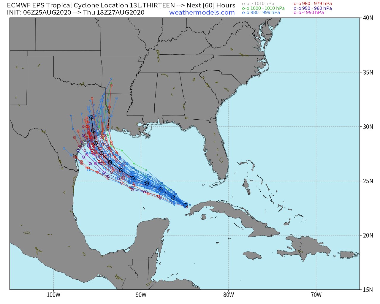
Laura is predicted to be a major hurricane (Category 3 or higher) at landfall.  The track has been slightly west of forecast so far, and further shifts west are possible today.

Image from: http://www.atmos.albany.edu/facstaff/tang/tcguidance/

Residents all along the Central/Northern Texas coasts into SW Louisiana should be prepared for impact from a very strong, likely major hurricane.

Image from www.weathermodels.com

How is this Different from Harvey?

Residents in this area are still probably dealing with trauma from Hurricane Harvey (and also TS Imelda last year), which brought enormous inland flooding.  Laura will be a different storm in a LOT of ways, some good, some bad.

Good Difference from Harvey (Rainfall)

1. Laura will be moving faster than Harvey, which will significantly lower the inland flooding threat. Now, flooding can and will still happen especially in vulnerable areas, but it should not be nearly as widespread.

Bad Differences from Harvey (Wind and Storm Surge)

1. Laura will be moving faster, so it won't weaken as quickly moving inland, and strong, damaging winds will extend well inland into Texas and Louisiana.
2. Laura will be bringing its storm surge into a more populated area than Harvey did. 

If you live along the Texas or Louisiana coasts, finalize hurricane preparation today, and take this one very seriously.

Saturday, August 22, 2020

Watching Laura and Marco

 Hi Everyone!

The Atlantic has gotten busy as advertised, with two tropical storms in the Caribbean today: Laura and Marco. I'll spend a little bit of time on the forecast for each. I'll start with Marco because although it formed later, it will likely impact the U.S. first.

Tropical Storm Marco

Tropical storm Marco is currently over the Northwestern Caribbean, heading for the Yucatan Channel. It is strengthening right now, and might very well become a hurricane today.

Image from www.weathernerds.org

Marco should weaken some in the Gulf due to wind shear, but could still impact the northern Gulf Coast as a strong tropical storm. The storm could impact southern Louisiana if it stays stronger, but might bend back towards the west into Texas if it's a weak storm.

Image from www.tropicaltidbits.com

The current official forecast from NHC brings Marco in NE Texas as a tropical storm late Tuesday.

cone graphic

Tropical Storm Laura

Tropical Storm Laura is near Puerto Rico this morning. It has been poorly organized for a while, but might be trying to get stronger today.

Image from www.weathernerds.org

Laura has been a tricky storm to forecast. For a while, the models were suggesting the storm would track north of the Caribbean Islands and towards South Florida or the Florida Keys. But because of some changes in storm structure and large-scale wind patterns, it looks like a track along the Caribbean Islands and then into the Gulf of Mexico is likely. 

Image from www.weathernerds.org

The intensity forecast is tricky (as is often the case). Conditions over the Gulf of Mexico should be very, very favorable for the storm to intensify. However, it will first have to pass over the Caribbean islands of Hispaniola and Cuba, which are mountainous in spots and can disrupt circulations. The longer the storm has over the Gulf of Mexico after it moves off Cuba, the stronger it will likely be. Anywhere from the FL Panhandle to the Texas coasts should be keeping a very close eye on Laura. The official NHC forecast for Laura brings it into Louisiana as a hurricane Wednesday. This can change, so be vigilant!

cone graphic
Image from www.nhc.noaa.gov

Will Laura and Marco Interact With Each Other?

Some earlier forecasts had suggested that Laura and Marco would get close enough to "spin around" each other in what is known as the "Fujiwhara Effect".  This is still possible, but seems less likely today. That being said, there is still enough uncertainty with both storms that residents all along the Gulf Coast should start making hurricane plans!

Andy