Tuesday, August 25, 2020

Hurricane Laura a Major Threat to The Texas/Louisiana Coasts

 Hi all,

Quick update on Laura, which is now a hurricane. 

Image: www.weathernerds.org

Laura is predicted to be a major hurricane (Category 3 or higher) at landfall.  The track has been slightly west of forecast so far, and further shifts west are possible today.

Image from: http://www.atmos.albany.edu/facstaff/tang/tcguidance/

Residents all along the Central/Northern Texas coasts into SW Louisiana should be prepared for impact from a very strong, likely major hurricane.

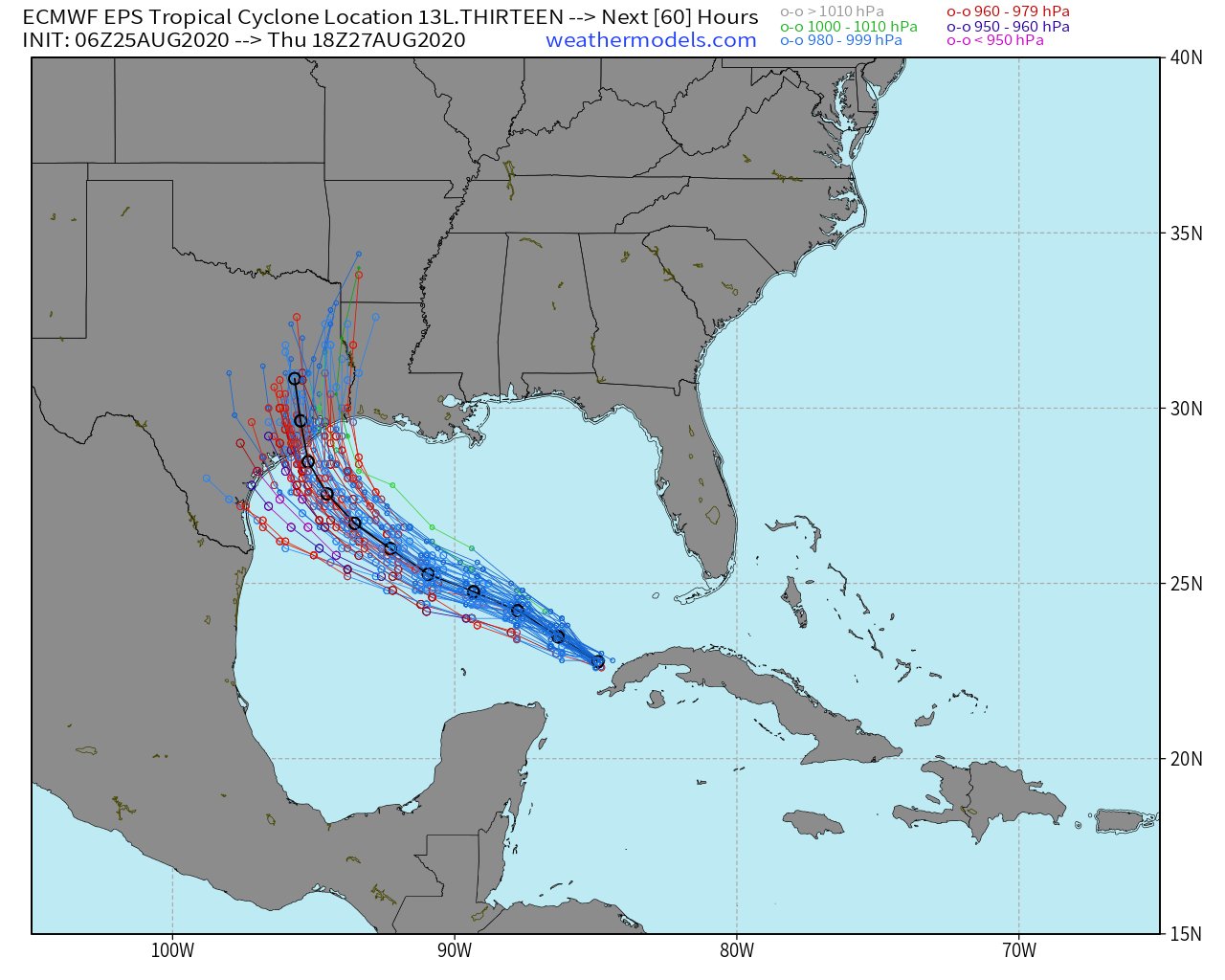
Image from www.weathermodels.com

How is this Different from Harvey?

Residents in this area are still probably dealing with trauma from Hurricane Harvey (and also TS Imelda last year), which brought enormous inland flooding.  Laura will be a different storm in a LOT of ways, some good, some bad.

Good Difference from Harvey (Rainfall)

1. Laura will be moving faster than Harvey, which will significantly lower the inland flooding threat. Now, flooding can and will still happen especially in vulnerable areas, but it should not be nearly as widespread.

Bad Differences from Harvey (Wind and Storm Surge)

1. Laura will be moving faster, so it won't weaken as quickly moving inland, and strong, damaging winds will extend well inland into Texas and Louisiana.
2. Laura will be bringing its storm surge into a more populated area than Harvey did. 

If you live along the Texas or Louisiana coasts, finalize hurricane preparation today, and take this one very seriously.

Saturday, August 22, 2020

Watching Laura and Marco

 Hi Everyone!

The Atlantic has gotten busy as advertised, with two tropical storms in the Caribbean today: Laura and Marco. I'll spend a little bit of time on the forecast for each. I'll start with Marco because although it formed later, it will likely impact the U.S. first.

Tropical Storm Marco

Tropical storm Marco is currently over the Northwestern Caribbean, heading for the Yucatan Channel. It is strengthening right now, and might very well become a hurricane today.

Image from www.weathernerds.org

Marco should weaken some in the Gulf due to wind shear, but could still impact the northern Gulf Coast as a strong tropical storm. The storm could impact southern Louisiana if it stays stronger, but might bend back towards the west into Texas if it's a weak storm.

Image from www.tropicaltidbits.com

The current official forecast from NHC brings Marco in NE Texas as a tropical storm late Tuesday.

cone graphic

Tropical Storm Laura

Tropical Storm Laura is near Puerto Rico this morning. It has been poorly organized for a while, but might be trying to get stronger today.

Image from www.weathernerds.org

Laura has been a tricky storm to forecast. For a while, the models were suggesting the storm would track north of the Caribbean Islands and towards South Florida or the Florida Keys. But because of some changes in storm structure and large-scale wind patterns, it looks like a track along the Caribbean Islands and then into the Gulf of Mexico is likely. 

Image from www.weathernerds.org

The intensity forecast is tricky (as is often the case). Conditions over the Gulf of Mexico should be very, very favorable for the storm to intensify. However, it will first have to pass over the Caribbean islands of Hispaniola and Cuba, which are mountainous in spots and can disrupt circulations. The longer the storm has over the Gulf of Mexico after it moves off Cuba, the stronger it will likely be. Anywhere from the FL Panhandle to the Texas coasts should be keeping a very close eye on Laura. The official NHC forecast for Laura brings it into Louisiana as a hurricane Wednesday. This can change, so be vigilant!

cone graphic
Image from www.nhc.noaa.gov

Will Laura and Marco Interact With Each Other?

Some earlier forecasts had suggested that Laura and Marco would get close enough to "spin around" each other in what is known as the "Fujiwhara Effect".  This is still possible, but seems less likely today. That being said, there is still enough uncertainty with both storms that residents all along the Gulf Coast should start making hurricane plans!

Andy


Wednesday, August 19, 2020

A Few Things To Watch in the Atlantic

 Hello Everyone!

As I mentioned the other day, the Atlantic is starting to heat up. There are 3 systems all worth watching right now.

Image: www.weathernerds.org

System 1 (Invest 97L)

The first system, right now classified as "Invest 97L" (meaning it's an area of interest being wathced by NHC), is a tropical wave moving through the Caribbean. It will likely not develop for a few days, but should be watched carefully for possible development when it gets near the Yucatan Peninsula. The Central and Western Gulf of Mexico should especially keep an eye on this one.

System 2 (Invest 98L)

This wave, over the Central Atlantic right now, is definitely one to keep a close eye on. This wave will likely become a tropical depression or a tropical storm in the next couple of days, and will pass near the Virgin Islands by the end of the week. It could be a threat to Puerto Rico, Hispaniola, Cuba, the Bahamas, Florida, and maybe even the Gulf, all depending on the exact track it takes. Below is an "ensemble" of model tracks showing some of the possible outcomes. 


Images from www.weathernerds.org

If the system spends a lot of time over the Caribbean Islands, it will probably not develop much except maybe later in the Gulf of Mexico. If it develops earlier and gets a little further north, it might be something for Florida to watch by early next week. Lots of possibilities are still on the table with this one. It's too early to say when this will develop and where exactly will be impacted, but it's looking like this could be a threat to a lot of landmasses in the Gulf/Caribbean area, so now is a good time to start hurricane preparations. 

3rd System

The final system for now is a strong wave moving off Africa. If it develops quickly, it will probably curve out to sea, but it's really too early to tell for sure. Lots of time to watch this one, but it does look like we are headed for a busy peak to the hurricane season, so be ready!

Andy