Sunday, September 22, 2019

Tropical Storm Karen Forms, Worth Keeping an Eye On

Hello Everyone!

A new tropical storm, Karen, has formed in the Eastern Caribbean, near Trinidad and Tobago. 

cone graphic
Image From www.nhc.noaa.gov

The storm is forecast to move to the northwest and then north, probably passing near Puerto Rico and the Virgin Islands in a couple days. From there, the track could get tricky.  It's possible the storm could scoot out to sea, but there is a big ridge of high pressure forecast to form to the north.


Image From www.tropicaltidbits.com


If Karen gets under this ridge, it could get forced back to the west or southwest.  This is reflected in some of the ECMWF ensemble solutions.  So this could be something for the Bahamas and Florida to watch by next weekend.


Image From www.weathernerds.org

So it's too early to worry too much, as a lot could change, but this could be one to watch!

Remember to check www.nhc.noaa.gov for the latest official information.

Andy

Thursday, September 12, 2019

The Atlantic Tropics are Coming to Life Again

Hello Everyone,

After a short break post-Dorian, the Atlantic tropics are coming to life again. 


Image From www.nhc.noaa.gov

The National Hurricane Center is highlighting two areas of concern.

Bahamas Wave (Invest 95L)
The system of more immediate concern is a trough of low pressure in the Bahamas.  It is not a tropical depression yet, but is forecast to become one soon.  Satellite imagery shows a broad area of showers and thunderstorms trying to coalesce.

Image From www.weathernerds.org

The forecast for this system is tricky. Some models bring it across the state as a weak tropical storm.  Others keep it offshore of Florida, but turn it into a significant hurricane that could threaten the U.S. East Coast.  Either way, the Bahamas appear likely to get more wind and rain this week - not nearly as bad as Dorian, but something they don't need.  Due to the uncertainty in the forecast, people along both the Gulf and East coasts need to keep a close eye on this as we head towards the weekend.  An Air Force Hurricane Hunter flight is scheduled to check out the area this afternoon.

Image From www.weathernerds.org


Atlantic Wave

There is another wave way out in the Atlantic that is moving towards the Caribbean.  It may not develop for several days, but models show a chance of it becoming a tropical storm or hurricane in the Caribbean, and following the path of several storms this year it could move towards the Southwest Atlantic afterwards.  This is still a long way out, but it's a good reminder to be ready as the peak of the hurricane season looks to be a busy one!

As always, get official hurricane info from the National Hurricane Center at:

www.nhc.noaa.gov

Let me know if you have any questions!

Andy

Monday, September 2, 2019

Dorian Stalls Over the Bahamas, Will Pass Very Close to the Florida East Coast and then the Carolinas

Hello everyone,

Finally back from flying into Hurricane Dorian from last Monday to Saturday.  It was pretty insane to see the storm go from a tiny, weak system way out into the Atlantic to a monstrous Category 5 over the Bahamas.  Yesterday, it reached winds of 185 mph, tied for the second-strongest hurricane in Atlantic history.

The storm currently has winds of 165 mph (still a Category 5) and has slowed to a crawl, and is currently basically halted right over Grand Bahama.

Click for latest Long Range Base Reflectivity radar loop from the Miami, FL radar and current weather warnings

This is awful news for the island of Grand Bahama, and nasty weather is still battering Great Abaco where Dorian caused devastation yesterday.  Keep those people in your prayers - they will need all sorts of help when Dorian clears out.

U.S. Impact

The storm is currently forecast to take a track just, and I mean just, offshore of the Eastern Florida coast.

cone graphic
Image from www.nhc.noaa.gov

It would not take much for the strong eyewall winds, storm surge, or even the eye of the storm to actually directly impact the East Coast, especially in the area from around Jupiter up through Jacksonville.  Hurricane watches and warnings have been issued for much of the Florida East Coast.  The storm will then pass very close to or over the coasts of Georgia, South Carolina, and North Carolina.  Notice that the NHC cone even suggests there could be impacts further up the Atlantic coast.

Notice that the GFS (American) weather model is showing a huge area of rain in excess of 6 inches all along the East Coast of the U.S., so flooding (especially when exacerbated by strong onshore flow) will be a problem for many areas.


Image from www.tropicaltidbits.com (Levi Cowan)

The impacts to inland Florida are *hopefully* looking better, but I wouldn't let your guard down until the storm clears.  And many areas of coastal Florida, Georgia and the Carolinas are already under evacuation orders, so if you live there, make sure to listen to local authorities.

I'll keep everyone updated as Dorian's U.S. approach comes into view!

Remember to get official hurricane information at www.nhc.noaa.gov.

Andy

Tuesday, August 27, 2019

Tropical Storm Dorian Weak for Now. Watch and be ready!

Hello everyone!

I'm writing this from St. Croix, after the NOAA plane finished our first mission into Tropical Storm Dorian last night.

The storm is still fairly disorganized.  It looks somewhat impressive on satellite, but is fairly disorganized "under the hood".  This is why aircraft missions are important!

Infrared Satellite Image of Dorian (Image Credit Levi Cowan, www.tropicaltidbits.com)

The storm is currently forecast to stay weak for a few days, but could pose a flooding threat to Puerto Rico, the Dominican Republic, and other nearby islands.

The official forecast brings the storm (as a strong tropical storm) towards Florida by late this weekend.

cone graphic
NHC Official Forecast Cone and Watches/Warnings for Dorian

There is still a lot of wiggle room for these forecasts, however.  Given the current weak state, Dorian could just fizzle out when it gets close to the Dominican Republic.  However, if it holds together, the atmosphere in the Bahamas looks favorable for strengthening, and there is a chance it could be a hurricane by the time it gets near FL.  This is reflected in the ECMWF ensemble forecasts - some of them kill Dorian or keep it quite weak, while others have it strengthening and hitting Florida or even going into the Gulf.

ECMWF Ensemble Track/Intensity Forecasts (credit: www.weathernerds.org, Matt Onderlinde)


Bottom Line

It's still too early to determine Dorian's impact to the mainland US.  Impacts of at least flooding rain appear likely in Puerto Rico and the Dominican Republic (and later the Bahamas), so prepare accordingly there.  People from the Carolinas through the Gulf (and especially in FL) should make sure your hurricane plans are in place, and monitor notices from local experts and authorities.

As always, get official hurricane forecasts at www.nhc.noaa.gov.

Let me know if you have any questions!

Andy

Monday, August 26, 2019

Tropical Storm Dorian Could Pose a Threat - be Ready Just in Case

Good morning everyone!

As I posted last week, the Atlantic tropics have come to life a bit.  Tropical Storm Dorian is moving towards the Caribbean, and currently has 60 mph winds.


Image From www.weathernerds.org

The latest forecast from the National Hurricane Center brings Dorian to the Northwest, and near or over the island of Hispaniola in a couple of days.  People in the Windward Islands, Puerto Rico, the Dominican Republic, and Haiti need to be ready for tropical storm or even hurricane conditions.

cone graphic
Image From www.nhc.noaa.gov

This island interaction is one of the trickiest parts of the forecast for Dorian.  If it goes right over the Dominican Republic and Haiti, the small storm could get torn up and significantly weaken.  If it mostly avoids the island to the north, it could stay stronger and be a problem for the Bahamas, and even potentially Florida by next weekend.

Image from www.weathernerds.org

The image above is called an "ensemble" plot - it's a bunch of slightly different versions of the same model, in this case the European model.  You can see the ones that take Dorian towards Hispaniola mostly die out there, while the ones that track closer to Puerto Rico show it surviving and potentially strengthening in the Bahamas.

What should I do?

1. Follow official Dorian forecasts at www.nhc.noaa.gov

2. If you have interests in the Caribbean Islands (especially Puerto Rico and the Dominican Republic), be ready for a strong tropical storm (at least) impact in a couple of days.  Flooding and strong winds are possible.  Make preparations now.

3. For those in the Bahamas or Florida, it's not certain that Dorian will impact us, but it's best to be ready.  Check now and make sure your hurricane kit is ready.  Better to be safe than sorry! Dorian could be nothing; it could be a threat by the weekend.

Hurricane Hunter Flights

The Air Force and NOAA Hurricane Hunters will be sampling Dorian over the next few days, to get a better idea of its structure and where it might go.  I will be on the NOAA plane, with the first flight reaching the storm tonight.

I'll try to post an update when I can; it depends on how exactly the flights work out.

Let me know if you have any questions!

Andy

Friday, August 23, 2019

Atlantic Waking Up a Little Bit


Hello Everyone!

After a very quiet start to the 2019 Atlantic hurricane season, things are starting to pick up a little bit.  This is not surprising, as we are getting close to the peak of hurricane season, as this chart from NOAA shows:


There are a couple of specific areas worth watching right now, although neither is a huge concern yet.  The first is an area of low pressure off the Florida Coast.


Image from www.weathernerds.org

This system is forecast to develop into a Tropical Storm as it moves to the NE away from Florida early next week.  It will probably bring some heavy rain to the state this weekend.  It is worth watching in the Northeast, but hopefully won't be a major problem.

Image from www.weathernerds.org

The other system worth watching is a tropical wave way out in the Central Atlantic.  Satellite imagery shows a circulation trying to form.

Image from www.tropicaltidbits.com

This system is still several days from impacting any land areas.  The Leeward/Windward Islands and Puerto Rico and Hispaniola should keep an eye on it, but we still have time to watch and see if it develops into a tropical system.

Elsewhere, Tropical Storm Chantal has weakened to a depression way out over the North Atlantic, and is not a threat.  Some other strong waves are forecast to move off the coast of Africa over the coming week, which we will have to keep an eye on.

Bottom line - things are starting to pick up as they often do this time of year, so just make sure you are ready if you live in a hurricane-prone area! I'll update more if a system becomes a bigger threat.

Andy

Monday, July 29, 2019

A Couple of Things to Watch in the Tropics

Hello Everyone!

As we head into August, there are a few minor things to watch in the tropics, but nothing too concerning at the moment.

The National Hurricane Center has highlighted a tropical wave in the Caribbean for a 20% chance of becoming a tropical depression or storm over the next 5 days:


As you can see below, it's not a very organized system at the moment (image comes from www.weathernerds.org)


Still, it could bring some rain to Puerto Rico, Hispaniola, the Bahamas, and later Florida, so keep an eye on it!

Elsewhere, some tropical waves are rolling off Africa, but nothing is an imminent threat.  August - October marks the busiest part of hurricane season, so make sure you are prepared in case things ramp up quickly!


I will update if anything changes regarding the system in the Caribbean or any of the waves coming across.  As always, let me know if you have any questions!

Andy

Friday, May 24, 2019

Are We Going to Get Any Hurricanes This Year?

"Are we going to get any hurricanes this year?"

This is probably the #1 question that people ask when they find out I'm a hurricane researcher, especially now that we live in South Florida.  I wish I could provide an exact answer, but unfortunately our science is not at a point where I can answer that question with even moderate confidence.

There are several groups that do seasonal predictions of hurricane activity.  NOAA Released Theirs Yesterday.  These forecasts account for various things like ocean temperatures in the Atlantic (warmer water tends to favor hurricanes) and ocean temperatures in the Pacific (when the Equatorial Pacific is warm, called "El Nino", the thunderstorms there produce upper level winds that tend to destroy Atlantic hurricanes).  This year, there is a weak El Nino, but the Atlantic is also pretty warm, and Western Africa (the area where most Atlantic Hurricanes are born) is also fairly wet, which would favor Atlantic storms.  So there are a lot of competing factors, and it's too early to say if this will be a "quiet" or "busy" season.

The thing is, these seasonal forecasts, while quite interesting scientifically, simply predict how many storms will form in the entire Atlantic Basin over the whole season.  They don't tell you where the storms will go, or when they will be there.  There are researchers that try to assess the landfall risks in their seasonal outlooks (my friends at Weather Tiger are one), but that science is not to the point where we can say with any accuracy whether Miami, or Lakeland, or Tallahassee, or Houston, will be hit by a Category 3 hurricane this season.

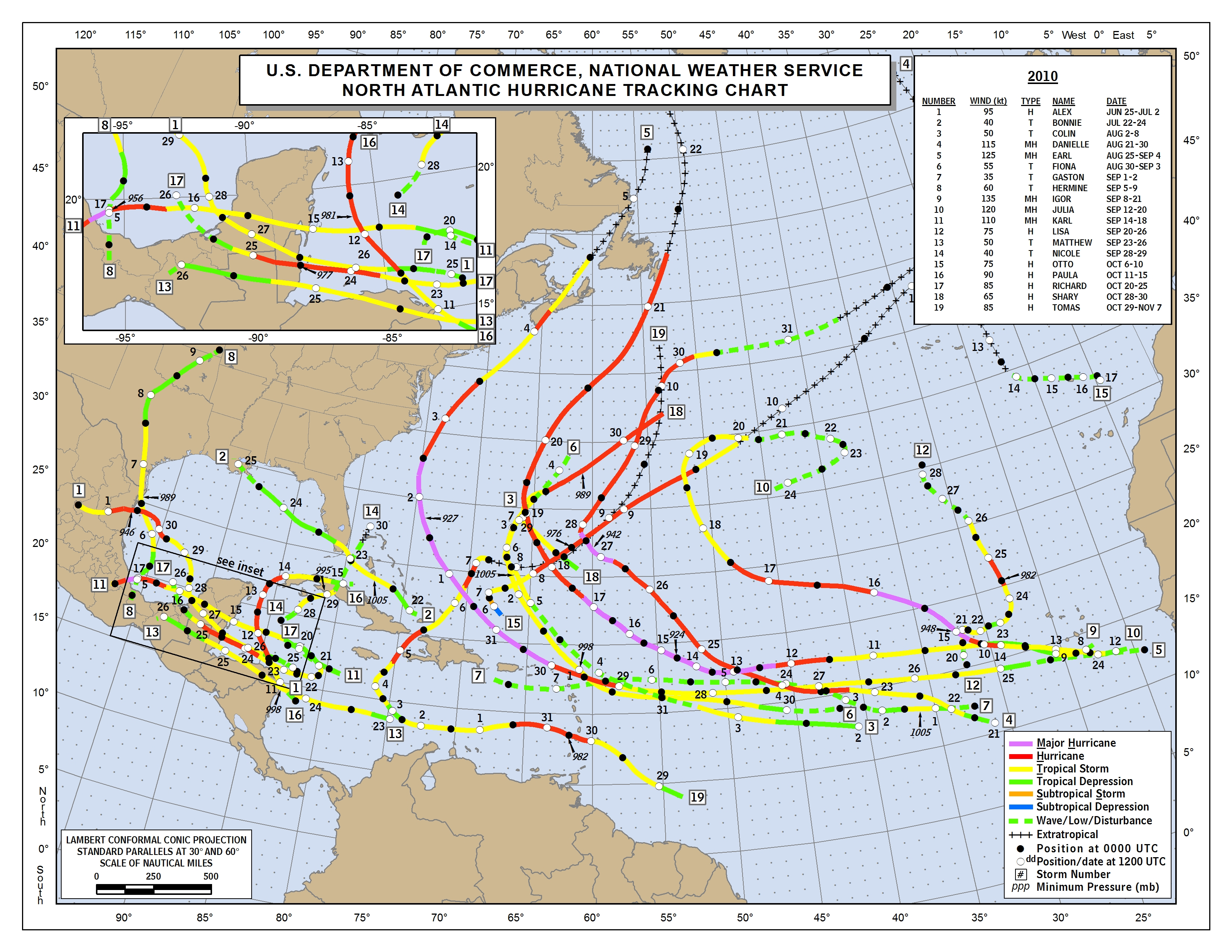
And it doesn't necessarily matter (for landfall risks) whether a season was "busy" or not.  2010 was one of the busiest recent seasons, but almost all big storms avoided the U.S.:

Image result for 2010 atlantic hurricane season

On the other hand, 1992 was one of the most overall inactive seasons in recent history, with only 6 tropical storms and 4 hurricanes:

Image result for 1992 atlantic hurricane season

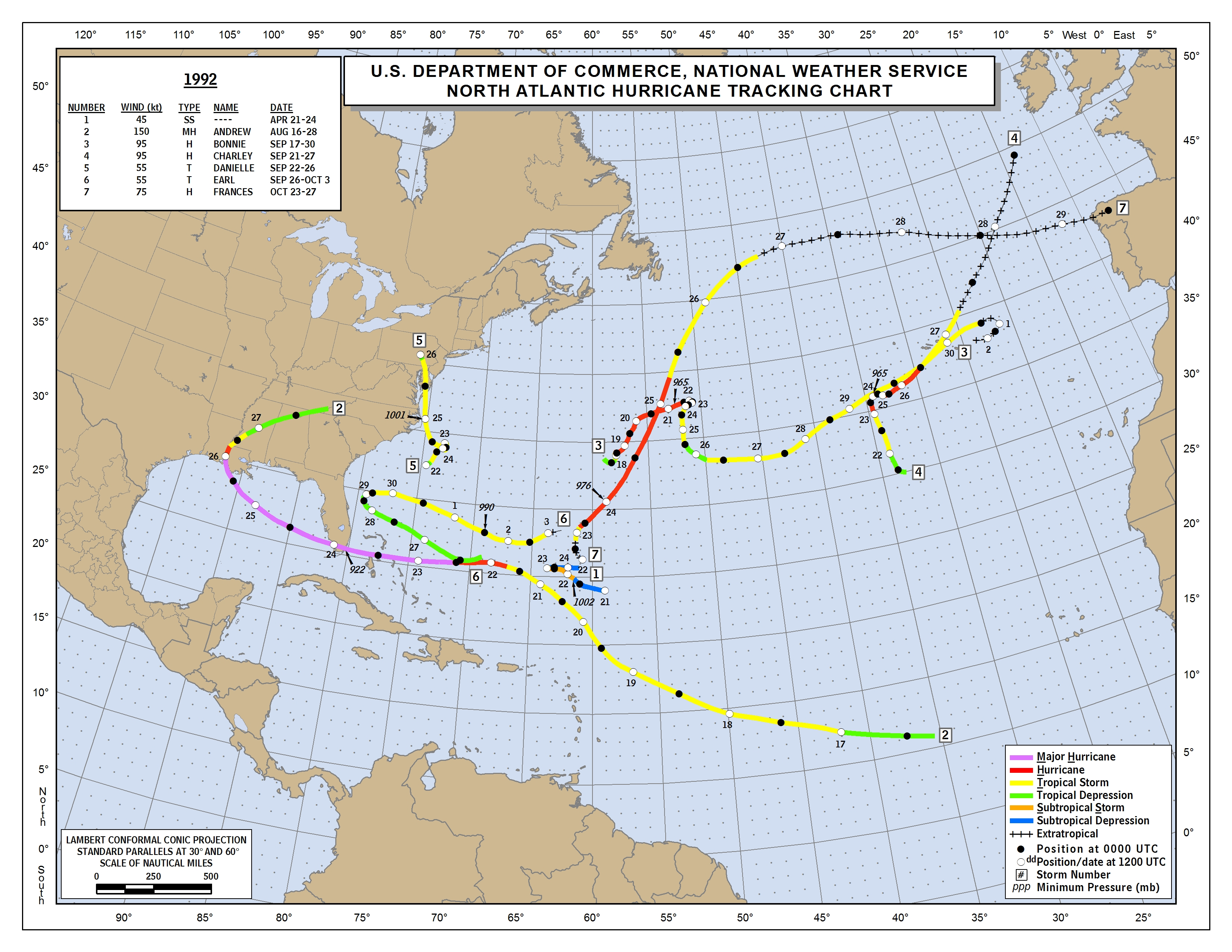
There was one that hit the U.S., however, known as Hurricane Andrew.  One of the worst natural disasters in U.S. history.

Image result for hurricane andrew satellite

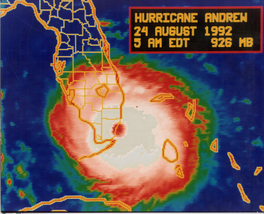
So you can see that bad hurricane hits can happen in "active" or "quiet" years.  The cliche saying is "it only takes one", and that is quite true.

It's a little depressing to know that we probably won't be able to tell you whether a hurricane could hit your house more than 3-5 days out, but the good news is that you can take this time before the busy part of the season to get ready in case one does come!

Here Are Some Hurricane Preparedness Tips

It's Also Important to Know if You Are in an Evacuation Zone

Hopefully, there won't be any bad hurricane landfalls, whether the Atlantic as a whole has 20 storms or 5, but just be ready either way!

Sunday, May 12, 2019

A Fascinating Structure in Hurricane Michael

Mesovortices in Hurricane Michael

By now, most people have heard that Hurricane Michael was recently upgraded from Category 4 to 5 at landfall.  I tuned in to a webinar recently where NHC Hurricane Specialists Stacy Stewart and Jack Beven explained the troves of data (radar, satellite, and aircraft) used in this decision.  The webinar should be posted online here soon:


One of the interesting things about this case that Stacy Stewart mentioned was the fact that the decision on what wind data to use was complicated by the presence of mesovortices in the eyewall.  Now, if you're not a hurricane person, you may not have heard of these.  Basically, they're small-scale cyclones (mesocyclones) in the hurricane eyewall.  A little bigger than a tornado, but much smaller than the scale of the storm itself.  They make the eyewall take on shapes like a triangle, or pentagon, or other shapes rather than the typical smooth, circular eyewall we see.  Here are a couple of radar images from during our last flight into Michael, illustrating these unusual shapes.


The mesovortices can cause small-scale local increases in wind speed.  This makes it hard to tell if the wind being measured by the plane/radar is representative of the hurricane circulation as a whole, or just the small-scale mesovortex (which typically don't last very long).  Now, as Forecaster Stewart mentioned, the difference doesn't matter to the people being hit by it (although they determined the winds were Cat 5 with or without these mesovortices, and there weren't as many in Michael by the time it made landfall).  But what's interesting to me is I was able to replicate this structure in a simulation of Hurricane Michael using a test model (called HAFS, the Hurricane Analysis and Forecast System) that is a high-resolution nested version of the FV3GFS model.

Here is a forecast for Michael at landfall (started using data from October 7, right after Michael formed) for 3 days later.  The track is just a little bit off (not bad for a 3-day forecast), and the storm is strong but not quite as strong as the real one (Category 4 in the model, Category 5 in reality).  


Now, go back an hour earlier:


Notice the mesovortex (enhanced vorticity) in the SW eyewall?  There were winds over 165 mph with that!  But then, an hour later, the feature was mostly gone, and the maximum winds were about 140 mph (again, the model forecast was not bad but overall a little weak).  I just thought it was interesting that you could see a feature like this in both the real storm and in the model!  

This was a pretty nerdy post - I'll probably write a couple more general ones about hurricane forecasting as Hurricane Season approaches :)

Andy